

The number of drone operations in today’s airspace has increased significantly as drones become part of our lives. According to the Federal Aviation Administration (FAA), there are over 1.5 million drones registered for commercial and recreational use in the U.S., a figure expected to grow exponentially in the next decade.
Although drones are becoming more popular, there’s a growing concern about the ability to carry out drone operations in different weather conditions. This is because drones are highly sensitive to changing weather conditions in low-altitude areas, which can potentially make drone navigation and coordination difficult.
This article dives into how drone operators can protect their aircraft by having access to adequate weather information.
How Weather Variables Affect Drone Operations
Drones, by their very nature, are highly vulnerable to weather conditions, including wind speed, precipitation, temperature, pressure, lightning, fog, and clouds. These elements can significantly affect travel distance and stability control.
For operators to improve drone flights, they must understand how each of these weather variables can affect the flight, whether directly or indirectly. So, here’s a peak into this:
- Wind – Of course, every remotely piloted aircraft system has a wind limit that is published in the flight manual. Sudden changes in the wind speed or direction can affect the stability of your aircraft. Additionally, high winds can carry debris into your drone or blow it off course. This makes it hard to control the drone during the flight, thus reducing flight duration, or even worse, causing a crash.
- Humidity/precipitation – Humidity levels have an indirect impact on drone flight performance and stability. Additionally, precipitation can potentially damage electrical components in a drone, making it inoperable. As such, most drones are limited in wet weather.
- Temperature – If the temperature levels exceed the safe limit for drone operation, some FMS components may fail. Similarly, colder temperatures reduce battery life substantially, which affects drone range and flying duration.
- Lightning – When lightning strikes your drone, or somewhere near the drone, there’s a decent chance that it would cause substantial damage to the drone and its functions.
- Visibility – Flying in foggy or cloudy conditions with low visibility can reduce the drone’s ability to collect visual data, which means you might end up wasting resources on unsuccessful flights.
It is clear that weather conditions have a strong impact on drone performance. For this reason, performing sufficient weather check is an essential part of the pre-flight checklist for every drone operator, whether you’re flying for fun or business operations.
As a drone operator, you have access to tons of weather services, including TV services, basic weather applications, the National Weather Service, and many more. However, these are only perfect for those seeking general weather knowledge.
Drone flights and other operations cannot rely on such weather data. Flying drones will require granular and customized micro-weather data coupled with predictive alerts for mission planning.
So, how can drone operators iron out these weather obstacles and make done flights more efficient? It’s pretty simple- leverage the power of an advanced micro weather API.
Using a Weather API for Drone Operations
When operating a drone, there are three possible flight scenarios as a result of weather conditions. The first is a normal flight procedure where the drone lands at the planned destination. Secondly, the drone can experience an inflight issue, and the flight management system commands it to return to its launch location.
Another scenario is when an in-flight problem can occur, causing the drone to initiate an emergency landing protocol.
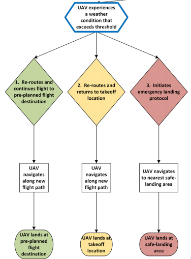
Possible flight scenarios where a drone experiences extreme weather conditions
Drone operators can initiate successful flights and responses to avoid crashes in any of the above scenarios by using real-time micro-weather data for the flight location.
The ClimaCell Weather API is a comprehensive micro weather solution that provides historical, real-time, and forecast weather data for every location across the globe. It can be used to optimize end-to-end drone operations through a single dashboard.
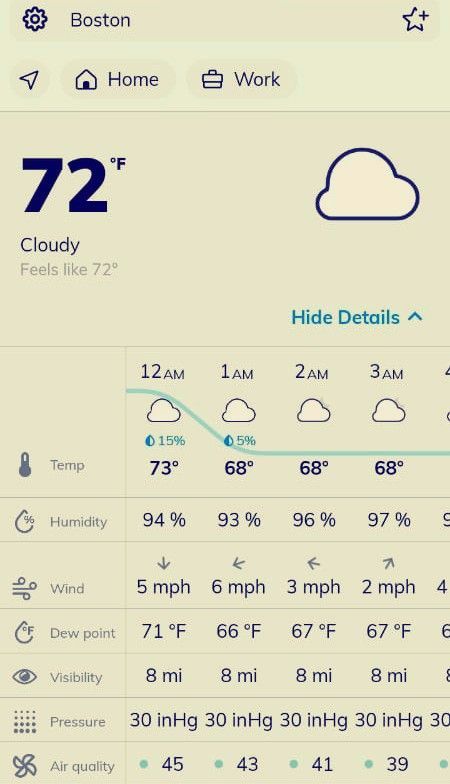
ClimaCell provides advanced micro-weather data for a range of elements that affect drone operations. These include temperature, humidity, wind, dew point, visibility, pressure, and air quality.
A drone operator based in Boston, for instance, can use the ClimaCell API to access these weather variables as shown below:
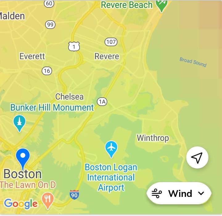
ClimaCell’s revolutionary approach for collecting hyper-local weather data makes it possible for drone operators to get the data they require for safe flights. All the weather data is accompanied by high-quality maps for every weather element in the target location.
Here is a map showing wind data for some parts of Boston on ClimaCell.
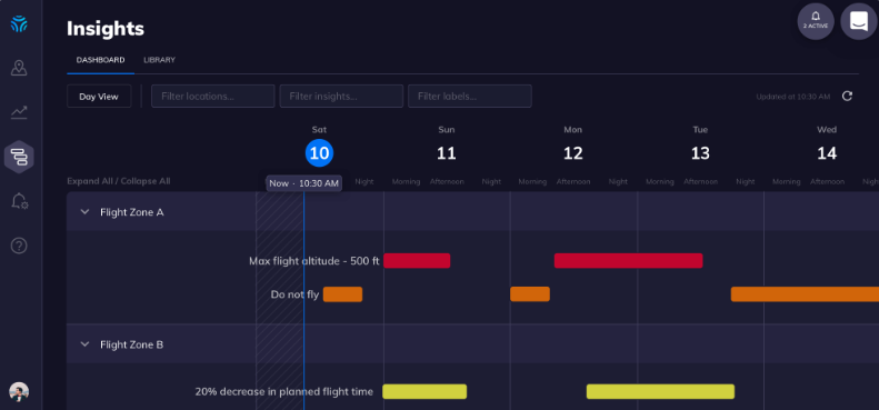
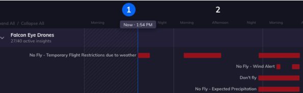
The ClimaCell Insights Dashboard provides every weather data drone operators need for a given day or week. This includes the time and day that flying your drone could be risky due to strong winds, cloudy conditions, and other weather parameters.
How does the ClimaCell API Streamline Drone Operations?
With its advanced weather data, the ClimaCell API improves drone flights across three main aspects: pre-flight planning, in-flight operations, and post-flight analysis.
Pre-flight planning
Advanced weather data from the ClimaCell API allows operators to plan drone missions at the most convenient times. Since ClimaCell offers precise hyper-local forecasts, you can easily determine the best location and time for flying.
Additionally, you can route the drone in the most visible path of flight, so that harmful weather does not derail operations. This ensures your drone operates in optimal flying conditions, thereby maximizing the flight efficiency.
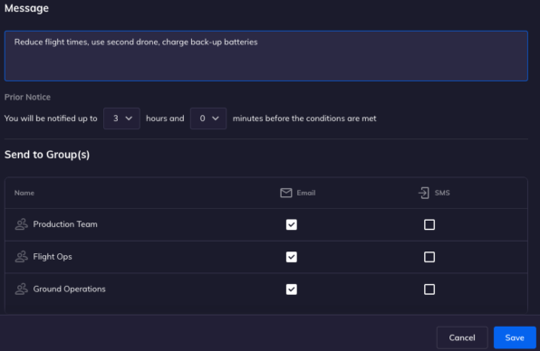
ClimaCell goes beyond providing basic weather information. It improves communication so that everyone in your team can stay on top of things. Through the ClimaCell dashboard, you can message other team members via email, text, slack, or your preferred communication platform.
In-flight operations
Weather conditions affect a number of in-flight variables such as flight elevation, path direction, and mission duration. ClimaCell provides real-time data from ground to cloud that Let drone operators know when to re-route the aircraft and manage safety issues.
This is especially important because most drones operate between an altitude of 10 and 400 feet – a range that’s too low for wind data meant for airlines yet too high for ground-level wind data.
ClimaCell addresses the challenge of obtaining low-altitude data by providing precise wind speed and direction for varying altitudes. This means drone operators can keep their aircraft in the best path and height of flight for the desired flight duration.
Post-flight analysis
Operators can use data collected from drone flights alongside weather data to assess the overall impact weather has on drone flights. This data can be analyzed and used to guide drone navigation in future. As such, drone operators will have an easier time making their future missions a success.
Integrating an advanced hyper-local weather API to your drone flight management system can improve your done operations significantly. You can easily answer questions such as “Can I schedule my drone operations right now?” or “Can I fly today at 1600 hrs and complete my mission?”
Additionally, you have a system to monitor and notify you of weather threats that might affect the drone before and after the flight. Ensuring drones can assess this data is not only helpful for operators but also for regulators and consumers. This is because drone operators can safely fly drones and complete their missions in the communities they operate.